Clevedon 7th April 2024

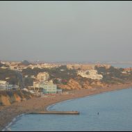
The seaside town of Cleveon is a little under an hour’s bus ride from Bristol. Time for a day out, even though the weather was cold and windy. After heavy overnight rain, thankfully it was dry. Bus fares in England are still capped at a maximum £2 for any journey. The buses used on the routes to Clevedon are double-deckers, affording a good view of the mostly pleasant, agricultural landscape.

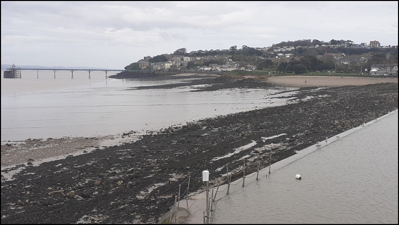
The beach at Clevedon is rocks, shingle and mud. The tide was out. Despite the windy and cold weather, a few stoics were out there with their children. The children seemed happy enough, searching the rockpools for creatures.

Clevedon Pier was opened in 1869, initially for a ferry crossing to take railway passengers to Wales. Cardiff is about 13 miles (28km) across the Bristol Channel. That’s Wales in the dim distance below. The opening of the Severn Tunnel put paid to that after only 20 years. The pier was used by pleasure steamers for much of the next 100 years. It is owned by a trust. There is an admission fee to be paid. Detailed Wikipedia article here. The area of the beach close to the pier is designated a Site of Special Scientific Interest. A variety of unusual rocks can be found there.

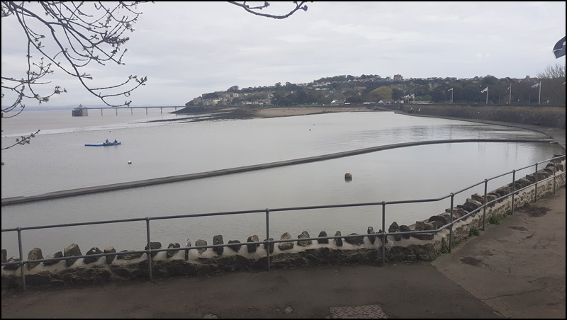
Clevedon also has a Marine Lake, a kind of salwater bathing pool. Opened in 1929, it provides safe bathing. The water is regularly refreshed by the high tides of the Bristol Channel. It is maintained by a volunteer group – website here. Not many takers on a cold Sunday morning but I did see a small group braving the elements.

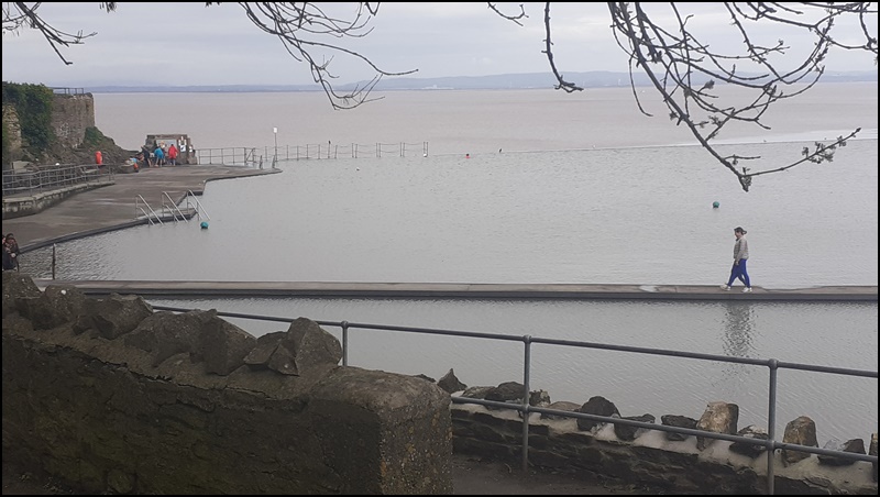
The wall across the lake encloses a shallow area for children.

Bristol Sunday 7th April

I spent the morning looking at other parts of the city I used to know. A big office block where I frequently had to visit for work was demolished a long time ago. Tollgate House it was called, near where Cabot Circus now stands. The pub we used to go to, The Phoenix, is still there. I was able to get a better look at the big white boat with the helicopter on the back. It is an actual ocean going yacht, not a night club as so many others are. It’s a private vessel owned by a group of locals. It has a colourful history which can be seen on their website https://www.missconduct.com/

If you didn’t know the city, you might mistake this for a stately home or maybe an ecclesiastical building. Wrong! This is the original Temple Meads railway station, designed by Brunel and opened in 1840. It last saw trains in 1965, having been replaced by a much larger and more suitable station next door. The building has been used for exhibitions and special events, although at the time of my visit it looked as if it hadn’t been used for a long time, fenced off in part.

It’s almost impossible to get a picture of anything in Bristol without cars interfering!

This is a church, St Mary Redcliffe. Parts of the building date to 1185, but like any old building it has been much altered over time. The spire, which I could not get completely in the picture, is 274 feet (83.5 metres) tall and one of the tallest in the country.

These are the kind of places I like to see – and visit. The Hole in the Wall is located in The Grove, just off Queen Square in the city centre.

The Hatchet is in Frogmore Street, just to the north of the city centre.

This is Queen Square. It was the centre of the 1832 riots I mentioned in my previous post. The houses of the wealthy were looted and pillaged by the mob, changing the character of the area for a long time! There are still large and elegant properties, many now converted to offices.

Out in the Harbour, the former tugboat John King was giving rides.

Across the water, some of the old buildings still stand among the new. Now known as Capricorn Place.

The big vessel is the Thekla, a German built cargo vessel converted into a music venue. It’s moored at the splendidly named East Mud Dock, near Queen Square.

Bristol April 2024

It has been very windy and feeling cold all the time I have been here! And it’s been raining on and off. But I did manage a few hours walking around the city on Friday. Much has changed since my last visit, much has not. Here are a few pictures, taken on my phone since I forgot to bring the camera charging cable!

Bathurst Basin – these little backwaters can be found all over the city. Bristol is builton rivers and canals. The lock gates have long since rotted away, the lock silted up and the water the preserve of ducks. Access from the other end is still possible.

All that remains of the ‘new’ Bristol Gaol in Cumberland Road. Built in 1820, it was largely destroyed in the Bristol riots of 1831 and rebuilt. It lasted only until 1883 when replaced by a new prison. It was demolished in 1898, apart from the gatehouse which remains.

The nearby Goal Ferry bridge dates from 1935 and spans the New Cut canal. By that time, few ships used the waterway. The fixed bridge replaced the ferry. The bridge was repaired and restored in 2023 and is now fully open.

The lock gates at the harbour entrance are now rarely opened. In the background is the Clifton suspension bridge.

The Clifton Suspension Bridge is one of Isambard Kingdom Brunel’s masterworks. It dates from 1835 and is a toll bridge, used by vehicles crossing the river as it has done for almost 200 years. The works are open to visitors. I know people who will not walk across it. On a windy day it can be felt swaying slightly.

One of the many former commercial wharves and docks, now the home of pleasure and houseboats, lined with expensive houses. This is Poole’s wharf.

This sorry looking three-master sailing ship, the Fridtjof Nansen, was destined to be an educational sailing vessel taking young people on character forming journeys. Presumably for want of funding, it now lies sad and abandoned moored across from SS Great Britain.

Another of Brunel’s works. At its time, the largest passenger ship ever. The SS Great Britain lay derelict in the Falkland Islands until 1970, when it was towed back to Bristol and subsequently restored.

The colourful houses on the hill are typical of the city. The grey ship on the left is the Fridtjof Nansen.

The remains of the railways that served the docks until their closure in 1975 can still be seen here and there. On the other side of the river, the Bristol Harbour Railway preserves a short stretch of the system, with working steam locomotives running on summer weekends.

Not quite what I expected to see!

Nor this! Urban myth? What kind of crocodile would want to live in these cold and murky waters?

The view downriver from Castle Green. The castle is long gone, demolished after the English Civil War. Bristol was on the wrong, losing, side!

Where the castle once stood.

Castle Green and St Peter’s Church from the river. The latter is a bombed out ruin, a relic of the air raids on Bristil during World War Two. It was closed and under repair at the time of my visit.

Visit to Deal Castle, September 2023

A day off as it were, so I spent half a day in Deal, including a couple of hours at the castle. It was built in 1539 – 1540 under the orders of Henry VIII as part of a chain of coastal defences intended to deter a French invasion. It worked, because they didn’t. Built to a then revolutionary design, its rounded walls would deflect the cannon balls of the new technology of warfare. Not that the castle saw much actual combat, the only serious action being a three month siege during the English Civil War. The castle was held by Royalist forces, the King’s supporters. It was attacked by and eventually surrendered to the Parliamentarian army. During World War Two the town and castle were bombed by the Luftwaffe, resulting in the destruction of the captain’s house.

There is an infomative article with historic drawings and pictures on the English Heritage website at https://www.english-heritage.org.uk/visit/places/deal-castle/history-stories/history/

Below are my pictures. The rooms in the interior have no view of the outside world. being stationed there must have seemed like prison.

The dry moat.
Deal, the port without a harbour. The boats were and still are moored on the beach under the protection of the castle. Deal pier in the background.
These 32 pounder cannon date from the early 19th century. They never fired a shot in anger.
Various levels of the castle, the higher protecting the lower.
One of the larger interior rooms with vaulted ceiling.
The door to the powder magazine is coated in copper to avoid stray sparks.
The pump room.
Narrow passages connect the interior with the outer walls and gun ports.
The well. There is still plenty of water in it.
The entrance to the castle prison.
The gun ports were cleverly designed with smoke vents in the ceilings
View from many of the interior rooms. Hardly any daylight.
The view from even the higher status rooms was not much!
This door is studded with large nails to help stop axe-men from chopping it down.
A proper fireplace, very necessary on a cold winter day on the east Kent Coast
Brick ovens in the kitchen.

Deal is about 2 hours drive south-east from London on a good day. Frequent trains run from several London stations, the fastest journey being 1 hour 23 minutes from London St. Pancras. Trains can also be taken from London Charing Cross, Waterloo East or London Bridge. Although these take about 30 minutes longer, they might be quicker overall if staying nearby. Check https://www.nationalrail.co.uk/ for times and tickets.

Local trains and buses also run frequently from Canterbury, Dover, Sandwich and Ramsgate, which are all historic and interesting places to visit.

Back home to Albufeira on Tuesday, airline permitting.

Visit to Deal, Kent, September 2023

Before the cricket, I spent half a day in the town of Deal. Deal is a small town on the east coast of Kent. There is a lot of history around here, the town was mentioned in the Domesday Book of 1086. It’s known as the port without a harbour – the few remaining fishing boats work from the shingle beach. There is a long and informative item on Wikipedia at https://en.wikipedia.org/wiki/Deal,_Kent

The town many well kept old buildings, particularly along Beach Street.

This is Brewer Street

Dolphin Street, named after a long gone pub.

Middle Street. I couldn’t quite get the angle with the sun very low. These buildings from the mid 18th century.

Deal Pier. This most recent edition dates from 1957. It is 1026 feet (313 metres) in length. A popular place for sea anglers.

The Timeball tower. This was built in 1820 to carry a form of semaphore telegraph signalling along the coast for the Navy. Replaced later by the electric telegraph.

From 1855, the Tower carried a timeball. This was linked to the
Royal Observatory, Greenwich, by electric telegraph wires running
alongside the railway. At 1p.m. each day, a signal was sent from
Greenwich to all timeballs (including Deal) in England, thus
synchronizing their drops. This time signal allowed ships anchored in
the Downs to check the accuracy of their chronometers – essential
for accurate navigation – before setting off on long voyages. It
ceased official operation in 1927. [Extract from the Trustees website.]

The Timeball tower is open to visitors. Information at their website https://www.dealtimeball.co.uk/

Next stop, Deal Castle.

Canterbury, Kent, 25th September 2023

Just a few bits and pieces.

A name that the older among you will remember, FHW was a British shoe manufacturer and retailer from 1875 to 1996. Shoes used to be mended, not thrown away. This depot in Canterbury was one of the places they went to. It is now empty.

Rather older, one of the bastions along the line of the city wall alongside the river.

The river is home to many ducks. The green weed is on the river bed.

This swan was on its own, but there are a few more.

Westgate Gardens. Looks very tranquil, but the roar of traffic from the ring road just beyond the trees is incessant.

Next stop, Deal and the castle there.

Visit to Taunton, Somerset, September 2023

It has hardly stopped raining since we arrived here. Very little action on the cricket field. This has been the scene most of the time.

The County Ground, Taunton Tuesday morning. Covers on, no play.

Play eventually began around lunchtime.

Our view from the Marcus Trescothick stand. Somerset batting.
You would expect, in these high-tec days, that they would have a better sightscreen that a giant bedsheet, or perhaps it is a ship’s sail, tethered between two buildings!

There was no play at all on Wednesday, so we went to Glastonbury on the bus. But it was raining so hard all we saw of the town was the inside of two pubs and about 250 metres of the street between them!

This was a very nice pub. Almost a throwback to years gone by, it has three separate bars. A very good range of draught beer and cider available. Do visit if you are there.

Around here of course it’s all mystic stuff, Avalon and all that. This mural just about sums it up.

The Market House, opposite the bus stop for the journey back to Taunton. An impressive array of flavoured ciders on offer, including pineapple and rhurbarb. Stuart tried several and pronounced them good. I had a couple of mouthfuls, before returning to ale. Flavoured cider is not really to my liking, but nothing wrong with any of them. Certainly worth a try if you are in the area. Made by Lilley’s of Frome, find their website for their many varieties.

One we didn’t go into. It was raining reallt hard by then.

Before Taunton, I was off to Haringey Borough FC on Saturday to watch my former home town team, Tonbridge, play them in the FA Cup. Not a good day, lost 4-2. Mde up for it by the consumption of much ale. For those who don’t know, Haringey Borough FC is located in White Hart Lane, about a mile (1.6km) from the Tottenham Hotspur stadium.

Tonbridge in the light green shirts.
The ground is in area of warehouses and small industrial premises.

Last pictures from France

There’s no particular theme, just a few things that caught my eye. Now, I am all for using natural resources wherever possible but these are live power lines! Seen in Le Verdon.

The almost disused cranes at Le Verdon. The port is almost deserted these daya, although cruise ships do stop here for re-supply if they cannot get down the 60 miles / 100km along the river to Bordeaux. The tower was built as a water tower and apparently used as an anti-aircraft battery in World War Two.

One of the two ferries that cross the Gironde between Le Verdon (a different dock) and Royan.

The most often seen nautical activity in these parts.

The incredibly garish road markings appeared overnight in Le Verdon, along the road that leads to the ferry. I have never seen anything like this, anywhere!

And so it was down to Bordeaux for the final 36 hours before my flight back to Portugal. The train was incredibly crowded. There were more people sitting on the floor in my section that sitting on actual seats. SNCF, in its wisdom, decided that a 3 car train would suffice for a summer Saturday morning. The next train, which we passed on the way down , was six cars however.

To the Sunday morning ‘Brocante’ near the St Michel church. The bell tower is undergoing significant restoration. The scaffolding in place looks almost as impressive as the original structure, which dates from the 15th century. The tower is 114 metres (374 feet) high. When restored, it should be possible to visit it.

The market ranges from well ordered stalls selling ancient second hand books, postcards and records (black vinyl) and a lot of glassware, down to piles of stuff on mats and carpets. I have to wonder where the vendors get it from and more so to whom they sell it. OK dear, I will just pop out a buy a cannon. Or a set of cow horns, as one does.

Or, for that matter, a Second World War era rifle cleaning kit. I was tempted and did examine it. It looked complete and I did recall some of the tools from those long ago days in my schools Cadet Force. Cleaning Lee Enfield .303 weapons. Or perhaps take home a bear paw? Just what I always wanted!

Sme of you may be old enough to remember that this was how we used to buy nuts, bolts and screws. This stall had a huge box like this, probably from a store long since closed and forgotten. Note that they are sold by the dozen.

Look carefully above your head at the street signs and spot the previous names. Some have three, one pre revolutionary, one named after the heroes thereof and then later names like Rue Charles de Gaulle or Rue 8 Mai. This is one end of the well known shopping street.

After not having bought anything, a tram ride up to the rapidly changing area around the Bassins à Flot, the old docks. On the one hand there is lots of modernity.

But in areas yet untouched, flowers grow happily.

Looming large over the area is the Second World War submarine base, built by the Germans in 1941.

Every so often, you can trip over the remains of the area’s industrial past. But I was pleased to see that a lot of the old rails have been taken out of the ground and recycled as traffic barriers.

Last few days at the seaside in Soulac-sur-mer

It’s coming to the end of my visit. These are just a few images from the last few days.

There is a lot of very dense woodland around the area. Nice walks through them, but don’t sit down! To me, it seems that the biggest ants in the world live there, especially in the pine woods. Something else I have noticed over the years is the lack of birds, again especially in the pines. Hardly a wing flutters, nary a cheep is heard.

Then right in the middle, this standard issue German light machine gun post. Guarding what I wondered. There is nothing to suggest anything to be guarded. Behind it is a modern campsite.

The inexorable advance of the sea is exposing various layers of coastal defences and the traces of the railways used to bring the materials to build them. The higher ones date from the 1960’s, the lower structures nearer the sea from the 1920’s. This is to the north of the town. The 30 metre high dunes are gradually being pushed back.

The lagoons created by the tides are popular and safe places for children to play in the water.

The town has hired in a variety of equipment to suck and sweep that sand that was blow into the streets last week, to return it to the beach where it belongs. It does not take much imagination to picture the situation in 1741 which caused the original town to be evacuated and moved wholesale inland. The ancient church (Basilique Notre-Dame-de-la-fin-des-Terres) which I have pictured previously was buried up as far as the clock tower before it was unburied and restored in the mid 19th-century.

Another ever present danger in the area is fire. Last summer the forest trails were closed because of the extreme fire risk. Happily this year they are not, but to the south of the town along the beach there are often very large lumps of charcoal exposed. These are the legacy of a huge fire that ravaged the area sometime in pre-history. This one was about 1.5 metres long.

Seepage of oily water can be seen in many locations. The result of natural processes under the sand and exposed where the dunes are carved by the sea.

Elsewhere are distinct layers where icy cold water drips down from little escarpments. The sand is always on the move. Every now and then some artifact from ancient or modern history will show up. Only last week a local showed up a police station with a bagful of World War Two ammunition. Probably the most well known is this 1st Century brass statue of a boar found in 1989. Always worth keeping your eyes open when walking along the beach!

And finally, as ever, the first Sunday in August saw the annual blessing of the sea by various clergy. That night was a spectacular fireworks display enjoyed by thousands. My couple of photos cannot possibly do it justice.

East of Soulac, the polders

To the east of Soulac are large areas of flat farmland, reclaimed from the sea with the help of Dutch engineers in the 17th and 18th centuries. Go out there on a bike and it’s possible to hear the sound of silence, the only noise being that of the wind. This is the area between the little village of Talais and the Gironde estuary. Huge flat fields, prairies almost, stretching far into the distance. The main crops are maize and sunflowers, although do also have cattle grazing.

Looking the other way, across the tidal mud flats towards the almost disused port of Le Verdon. Oysters are cultivated here.

On the way, I passed the little airfield outside the town. Parked there was this old Antonov AN-2 aircraft. This one is registered in Hungary and seems to used for parachuting by a French group. I found some old photos of military parachutists using it for training. Around 18,000 of these were built between 1947 and the 1980’s. Many are still in service in various far flung corners of the world.